|
Poly
Canyon Springs and Brizziolari Creek
|
|
|
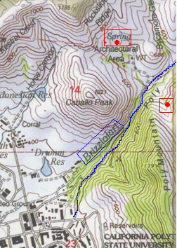
This map shows the three riparian areas we chose for this project. Brizziolari Creek is in blue and two springs that generate water for the creek are denoted by large red dots. For the sake of convenience, the spring on the left will be referred to as Spring #1, and the one to the right as Spring #2. Scroll across the map with your mouse to view descriptions and pictorial guides to any of these areas. |
|
|
|

