
![]()
![]()
![]()
![]()
![]()
![]()
![]()
![]()
![]()
![]()
![]()
![]()
![]()
![]()
![]()
![]()
![]()
![]()
![]()
![]()
![]()
![]()
![]()
|
Places
|
||
|
Explore Cal Poly Land by region. Each section listed includes maps, pictures, and guided tours by Cal Poly Faculty, who read the natural and human features of the landscape. |
||
|
[SLO Creek watershed] |
|
|
|
[SLO Creek watershed] |
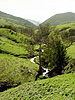 The watershed created by Brizziolari Creek,which originates on the steep upper slopes of Cuesta ridge, flows southwest through the rangeland of the old Peterson ranch, the gorge beside Poly mountain, the campus core and which terminates in Stenner Creek. Poly Canyon contains an ecological study area, botanical garden, architectural study area, and hiking trails.
|
|
|
[SLO Creek watershed] |
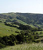 The watershed created by Stenner Creek, north and west of the central campus. It runs parallel to Brizziolari Creek, down Cuesta ridge, through the old Serrano Ranch, the Kirshner property, the gorge spanned by the Union Pacific railroad trestle, drains Cal Poly's agricultural lands and terminates in San Luis Obispo Creek near Marsh and Higuera streets
|
|
|
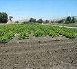
[Chorro Creek watershed] |
 Three thousand acres north and west of of Cuesta College and Chorro Park consisting of steep hillsides, several canyons and rich valley soil, drained by Pennington and Chorro creeks, range and agricultural land, functioning barns and residences, containing a 211 acre Biological preserve, and varied historical resources.
|
|
|
[Scott's Creek watershed] |
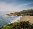 A 3200 acre seaside ranch in Santa Cruz County encompassing river-bottom cropland, mature redwood--douglas-fir forests, hillside rangeland and oak savannah. Includes organic vegetable farm, livestock herds, minature railway and historic buildings. Used for classes in agriculture, forestry, biology, and English. Home of planned environmental education center.
|
|
|
[SLO and Chorro Creek watersheds] |
 Lands bordering and between the University's two parcels in SLO County whose uses and abuses affect and illuminate Cal Poly Land |
|
 Lying
between the lower
Lying
between the lower